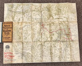
Natural Resources of Colorado and Utah: Map of the Denver and Rio Grande System and its Western Connections
Denver, CO: 1905. Color map (22 1/2" x 28 1/4"), folding into stiff paper covers (7 3/4" x 3 3/4"). Includes portions of Arizona, Colorado, Nebraska, New Mexico, Utah, and Wyoming. Shows standard gauge, narrow gauge, three rails, and connecting lines. The verso of the map is covered with printed..... More